We spend a lot of time in the prepping and survival community talking about TEOTWAWKI events. There’s some good reason behind that, as preparing for major disasters will help ensure that we’re prepared for the more common ones as well.
But in reality, the disasters that we are most likely to face are the natural disasters that plague our everyday lives, causing billions of dollars worth of damage and killing not a few.
It seems there is no part of the country that doesn’t have some sort of disasters we need to be concerned about. While we are all familiar with the biggest risks that we face wherever we live, few are familiar with the risks that exist in other parts of the country.
While it may not seem important to know what sorts of calamities someone living 1,000 miles away might be forced to face, none of us can foresee the future.
There’s a fairly good possibility that we might suddenly find ourselves living in another part of the country, facing disasters that we never faced before. A simple job transfer can cause that; but so can bugging out.
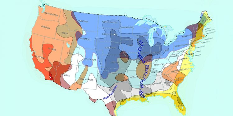
In order to help us all understand the various disasters we might face at some time in the future, I’ve put together the map below, showing the major natural disasters and where they are most likely to occur.
This doesn’t mean that the disaster can’t happen elsewhere; just that it’s more likely to occur in these parts of the country. Some things can happen literally anywhere.
Related: The Disaster Myth Narrative: No One Panics, No One Loots, No One Goes Hungry
We’ll start out with a combined map, showing all of the major groups of disasters and then look at each type of disaster individually.
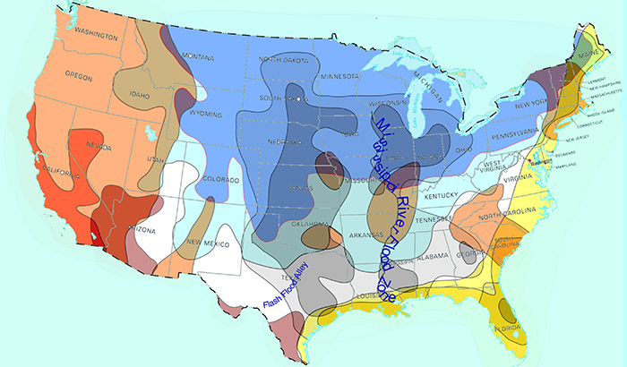
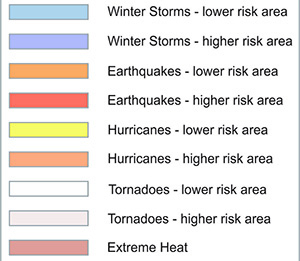
Here’s the key to that map:
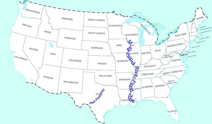
I realize that can be a bit confusing to look at, so I’ve broken it out by the various disasters below. A few things don’t have maps, because they can literally happen anywhere.
Floods
Floods are the single most common type of natural disaster we might face, pretty much anywhere in the country. Part of that is because other disasters can cause flooding as well.
Hurricanes and tsunamis can and do cause severe flooding. The flooding from Hurricane Harvey caused $125 billion in damage to the city of Houston; so do we call that a hurricane or do we call it a flood?
Related: 16 Things You Must Have in Your Stockpile for This Year’s Hurricane Season
While the flood damage from Hurricane Harvey was horrendous, the flooding caused by the Tohoku tsunami in Japan topped out at over $309 billion in damages.
Here in the US, the only tsunamis we’ve faced have been on the west coast and in Hawaii, and have all been associated with earthquakes. But by comparison to the Tohoku tsunami, those were small.
Flooding or flash flooding can reach pretty much any part of the country, even in the mountains.
Even so, the two areas of the country which have the most flooding are the Mississippi River watershed, which has many serious floods, especially as it moves farther south and what is known as “Flash Flood Alley” in Texas. Even though much of Texas is arid, flash flooding causes an immense amount of damage.
Tornadoes
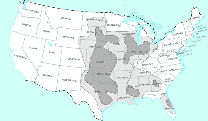
Tornado alley runs through the middle of the United States, essentially the nation’s breadbasket and accounts for over 1,000 tornadoes each year.
Unlike hurricanes, there is usually very little warning for tornadoes, making it hard to defend against and causing massive damage.
Tornadoes are funny, in that they can totally demolish one home and skip over the next, then go on down the street tearing up others.
Predicting their actions is all but impossible, as we are still learning about them. Nevertheless, they affect a large portion of the country.
Hurricanes and Tropical Storms
Hurricanes are spectacular in their impact and fury. It’s not unusual for a single hurricane to be more than 100 miles wide, causing damage over a huge swath of land.
This is a combination of both wind and rain damage, as hurricane force winds can reach over 150 miles per hour and hurricanes can dump rain that is best measured in feet, rather than inches.
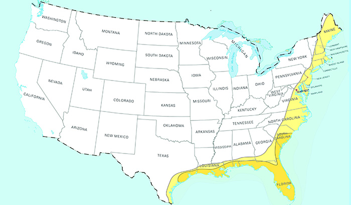
But while Houston was flooded by the rain of Hurricane Harvey, most of the flooding that comes from hurricanes is caused by what is known as “storm surge.”
This is the water that has been pushed up by the hurricane as it moves across the surface of the ocean. The record height for this is 27.8 feet, which came from Hurricane Katrina. When the storm surge is combined with wind and rain, it can demolish cities.
The only areas which are really affected by hurricanes are those which are close to the Atlantic Ocean, the Gulf Coast and Hawaii. You don’t really have to move all that far inland to reach the point where a hurricane is no worse than a serious thunderstorm; but within the coastal areas it can flatten homes and businesses.
You can find information about hurricanes and tropical storms at the National Hurricane Center’s website.
Earthquakes
Perhaps the scariest of natural disasters to be caught in is an earthquake. While other natural disasters attack the Earth, an earthquake is an attack from the Earth itself. The very ground beneath us haves and trembles, destroying some of mankind’s most impressive structures.
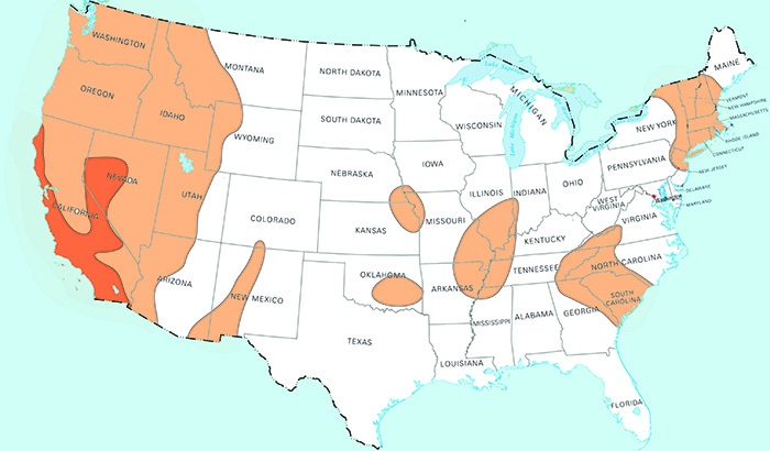
Most of the earthquakes that hit the United States hit the West Coast, especially Southern California. The west coast of the US is part of what’s known of as “the Circle of Fire” due to the vast number of still active volcanoes encircling the Pacific Ocean.
But the West Coast isn’t the only part of the country which can be hit by earthquakes. There are several other areas, shown on the map, which are susceptible to earthquake. They’re just not as well known as California, because California has more.
You can find a lot of information about earthquake monitoring and current earthquakes in real time at the USGS website.
Severe Winter Storms and Extreme Summer Heat
People don’t often think of winter storms and summer heat as natural disasters, unless they are something particularly unusual, such as the February Freeze of 2021.
Nevertheless, extreme cold and heat are serious problems, which we should treat with the same respect as we do any other natural disaster. Remember, it was the cold of winter that first taught our ancestors to prepare, as they wouldn’t make it through winter without having a stockpile of food.
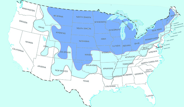
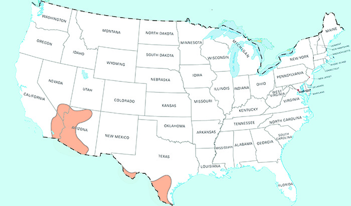
But for those who don’t have to worry about the winter cold and snow, there’s the risk of summer heat, which can be just as debilitating. While food still grows in the summer, there are some places where it can be dangerous to go out in the sun and cultivate that food.
Wildfires
I didn’t bother to include wildfires on the map, as it would have caused too much confusion.
Wildfires can happen literally anywhere there is forest. This means that the biggest percentage of them happen west of the Continental Divide, as that is the part of the country with the most forests. California is known for wildfires, in part because they don’t combat them effectively.
But the entire Northwest has problems with wildfires, as well as Colorado, New Mexico and Arizona.
Drought
Drought is also one of the natural disasters that’s impossible to map, because it can strike anywhere. However, some parts of the country are more susceptible to it than others, specifically the Southwest. But trying to define a drought area more specifically than that is virtually impossible, because it changes from year to year.
You can find accurate and up-to-date information about droughts in the United States from the NOAA website.
At the time of this writing (mid-2021), the Southwest is looking to face rather severe drought, but so is California. Even Northern California, which normally has plenty of water, is in trouble, with the Oroville reservoir being so low that they can’t produce electricity from it.
Power generation capacity from other reservoirs in California is not in much better shape, with a number of turbines about to be shut down.
You may also like:
13 Ways To Keep Your House Cool In The Summer
This Is How An EMP Will Affect Your State (Video)
Improvised Suppressors When SHTF: Keeping Quiet When It Counts
The Best Natural Treatments for Poison Ivy and Poison Oak Rash









I mean, pretty-good map …. for the most part. Couple of exceptions worth noting.
#1 – Here in SC we get hit with tons of tornados every single year especially through the middle of the state from Orangeburg up-to Newberry. It’s called tornado alley through this part of the state for a reason. Plenty of documented history. I’ve personally lived-through two very close calls myself. There is loss of life most every year here, along the belt, from tornados. Lake Murray up through Newberry especially.
#2 – The earthquake thing, while yeah, we do have trimmers now and then and there was that famous-one in Charleston a couple of centuries ago … we get little itsy bitsy baby tremors, pictures shake,,dishes rattle, little booms, sissy stuff like that. Preparing for a major earthquake here is probably a major waste of time, money and effort that is actually better spent-on preparing-for tornados, hurricanes, floods, EMP, drought, forest fires, and our most dangerous natural disaster threat here in SC, and around the south ….. Southern Belles. Southern Bells do more damage than anything else and they are generally considered the personal demonic tools, the henchwomen if you will, of Mother Nature herself. Her personal soldierettes. If you wanna see a path of destruction like none other simply follow the path of a Southern Bell. It is terrifying … no amount of insurance money can fix-it. What they destroy … it can never be rebuilt.
Well, Bless your heart! Those Southern Belles do do a lot of damage. Now don’t they.! Hard lessons learned years ago when I dated a Citadel Cadet. Such a shame I married him too!
Sooooo …. you were CofC? I get it.
You left out Alaska which, when I lived there, was still part of the USA…LOL. Earthquakes are common, as is extreme winter cold up in the Interior where we were.
Now living in Oklahoma, there are more earthquakes than I imagined, but much smaller ones. We get tornadoes, so everyone with any brains has a storm shelter, stocked for several hours. We did get subzero weather this past winter–unusual but it DOES occur, and killed much vegetation and trees that were not hardy. Also we get extreme summer heat and drought. July, August and September, sometimes into October. No rain and temps in the 100s. Not bad with city water and AC but if things went down, it will be hard to deal with. We live with these realities in mind and plan accordingly.
Rich:
Good overview, but you forgot blizzards, ice storms and the vicious coastal storms called nor’easters or sou’westers, depending on which coast you’re on. The latter two are basically off season hurricanes, clocking sustained winds up to 75mph and heavy rains.
I’m familiar with the east coast variety, but I think the basics apply to both.
If it’s cold enough, it will be an ice or snow event. You can get as much as 3-4 feet of snow with a lot of drifting. Usually storm conditions persist for 24-48 hours, but can last up to four days. Tornado and lighting risk is usually low with these events, but they often cause power outages, flooding, coastal erosion and heavy tree damage. Power outages can last from a few hours to a week or more, depending on more variables than I care to go into here. They can occur any time from mid autumn well into the early summer months.
Right on Miss Kitty! Nor ‘Easters do more damage around here on the north east coast than anything else! Years ago, I road one out in an attic apt on the beach in Hampton Beach, NH. Good thing I was high up as the rest of the place was washed out. Back in the day, there was little to no warning. All you could do was pray with out ceasing while you hung on to the plumbing.
it’s a crap shot deciding between “lower” and “higher” risk areas for earthquakes – but I tend to think of the New Madrid Seismic Zone at higher risk than low >> not only overdue for another major quake but has more potential destructive power than any of the CA coastal strings …
not even mentioned for natural disasters are tsunami – usually associated with offshore earthquakes >> the highest recorded tsunami wave occurred in Alaska at 1720 feet tall – regular alerts for tsunami for the entire Pacific Coast region …..
Yes and a 46’ tsunami which originated hundreds of miles away off the coast of Alaska hit Hilo Bay in 1920 prompting the creation of the Pacific Early Warning System. At the edge of the beach there is a plaque commemorating the hundreds of lives lost from that event, most of them school children as the school was situated right on the open bay.
I would have to agree with Illini. I have read first hand accounts of the terror and destruction created by the New Madrid earthquake of 1812. Severe tremors lasted for over a year. I am talking about earthquake level aftershocks. The Mississippi River reversed course with a resulting wave that anywhere else would be called a tsunami. It also changed its riverbed. Towns that were riverfront became some distance from the river and towns that had been inland of the river suddenly were riverfront property. During a tandem bicycle tour down the Mississippi River we visited a town with the name of Port (something or other. I forget its name) which at the time the town was founded, it was on the river which gave it its name. When we visited a year after Katrina it was located almost 20 miles inland. The Mississippi had moved that far west.
I won’t go into the details of all the phenomenon experienced by folks living in the area impacted by the New Madrid earthquake. I can just feel the terror that must have occurred when suddenly the ground beneath one started to shake and suddenly turned to quicksand and started to suck you under. Or a great chasm that opened up under your carriage as you were driving to escape the effects of the earthquake. The sudden appearance of life-threatening earthquake effects would have a significant morale affect on one. You are standing on solid ground and suddenly the solid ground becomes a quicksand pit sucking you down. Sure would ruin my day.
Rich omitted the factoid that the whole Pacific Northwest rests on the Pacific subduction zone and semiologists are all holding their breath because they anticipate, based on their measurements, that someday in the not too distant future they expect an earthquake and tsunami to match that whick occurred in 2011 in the Tohoku Region of Japan. If you live in Seattle or Portland, you would be well advised to own a Boston Whaler which is advertised that it will still float even if completely filled with water.
Then, too, there is the question of what Yellowstone will do. If Yellowstone erupts as it did in recent geological history as opposed to mankind history, the effect will cover the earth. We won’t be the only ones concerned about geological winter. Everybody will join in the misery.
Then we have Old Man Sun. It is my opinion that Earth will again experience a coronal mass ejection that will directly impact the earth with dramatic results. The Carrington Event is not the only such CME to visit earth within the last thousand years. As I write this I have received an alert from Spaceweather.com that a CME has impacted earth and caused a fissure in Earth’s magnetic field with BsubZ less than -10. No, it isn’t the big one that Red Foxx was always announcing, but it just reinforces the fact that CMEs occur with alarming frequency and it is only a matter of time until we are impacted with one that will result in damage to our infrastructure.
New Madrid Fault troubles are not all history…
The Navy has a map ( which Russia also has, interestingly) very similar to what religious seers are reporting about the Mississippi River:
after the next hugest of quakes U.S.A. will be physically divided into East and West lands….while my city, Chicago, will be part of the landmass that will be newly submerged beneath the deep waters..
Ergo,, dear East, Gulf & West Coasters: if you seek a place to move to be free of the coming coastal tsunami & hurricanes of CHANGE – Chicago is not the place.?
A YT channel called Suspicious Observer has some sun-related ideas.
you left out the creation of Reelfoot Lake – huge area alongside the Mississippi sunk and the river flooded it – still around for great fishing – lake of dead standing trees and stumps >>> today it would have population in an area like that – think about a similar area of St Louis going Atlantis …
while the PNW doesn’t get quakes as often as California there is Cascadia Subduction Zone and repeated warnings of “the big one”. I think they are talking about up to magnitude 12.0. Then the volcanoes…
SE Alaska has also had some very large quakes that included tsunami’s. 1964 m9.2 with tsunami.
Could have also mentioned the Yellowstone Caldera/Super Volcano. Anywhere remotely close to that could be pretty bad if it goes off.
Also the Mammoth, CA caldera is another active volcano whose eruption would have a major impact on, at a minimum, the central portion of western and midwestern U.S.
I called it the Pacific Subduction Zone, Manimal called it the Cascadia Subduction Zone. A subduction zone by any other name is just as dangerous. I think Manimal’s label is currently the more correct one.
The Mammoth Lakes caldera used to be called “the burnt land” by the native Americans who lived there. They thought the place was treacherous and a hazard to live close to. Caldera volcanoes are nasty entities; you don’t want to be close to one if it goes off. “Close”, as in closer than 20 or 30 miles if you want to live through the initial blast. And even then that might not be far enough. If you don’t want to be smothered in ash after the initial eruption you’ll need to be hundreds not dozens of miles away. And even that far away won’t help you if it’s Yellowstone that decided to pop… The Yellowstone caldera is not only large enough to easily be seen from orbit, it’s large enough to be mistaken for major geological land/valley formations. Laypersons would never think it was actually an enormous volcano crater that’s between 30 and 40 miles across. The hotspot that created the Yellowstone caldera is stationary, a hole up through the planet’s mantle, not unlike the Hawaiian chain of islands. As the continent slowly drifts towards the west, the hotspot keeps burning a “track” of huge tracts of scoured lands and pouring out enormous lava flows along the way, some of which have been hundreds of feet thick. Some flows from prehistoric times produced lava flood plains that were over a mile thick. Yellowstone gets its name from ryolite lava which is yellowish in color, surrounding the entire region with multiple flows which flooded the caldera many times. Mammoth Lakes is similar, just not as large… but it is very much active.
RM P
Chi-town wouldn’t be a good place for riding out a disaster for a bunch of reasons. Bad winters, hot summers, lots of people, high crime, crazy liberal politics, and only the Blackhawks are worth watching.
?. Too true not to be funny!!!
RM P – That maybe, but I’ll still be happy to take my chances at the 2021 Christkindlmarkt!
CC: Of course! But those vendors are not Chicago – they mostly come in from Europe! Hope they are permitted to visit again this 2021A.D…..?
Hurricanes are easy IF you build with solid concrete (yes, the roof, too), and do NOT build on the shore or an island. Guess what most folks do? Not these things!
On Okinawa I spent two years in a corrugated metal hut that had been built right after we secured the island, so by the time we moved in they had experienced numerous typhoons. We experienced several pretty good typhoons in that two year span but the hut continued to survive. How come? Well, it had reinforced cinderblock ends in the hut. It had heavy cables strung over the hut in —60 year old recollection — six places with the ends of the cables sunk into concrete pads that went quite deeply into the earth. At least six inches of the concrete blocks stuck out and I have no idea how deep they went. Also, every window had heavy wooden shutters that we put up upon receiving a typhoon alert which protected the windows from blowing out. The doors had latches and during a typhoon we stationed someone at the door to allow messengers to come into the hut. So you are correct, StBIG, constructing a building to withstand hurricane forces is feasible. I am afraid most folks don’t want to spend the extra money it takes to build a hurricane proof home. I see pictures of folks rushing to Home Depot to buy sheets of plywood every time a hurricane is predicted and I always think Why don’t they just have storm-proof shutters permanently installed on their homes? Save all that hassle ever time there is a big of wind.
Of course if you build in the surge plain, there is no cure for stupidity.
My cousin used to live in Brownsille, TX. His home has metal shutters that opended and closed with a remote control. It easily wIthstood hurricane winds.
Here in New Mexico commercial construction in my area has roof minimum load limits and pitch requirements. Thats because it isn’t unheard of to have a 3′ snowfal with a storm. Plumbing must be below 18″ which is an approximate freeze depth. We’ve had snow so deep the heater vent was stopped up and the LP heater couldn’t operate.
Good points, LCC!!! But remember too: not everyone can afford to fortify in the best way. Even more – after one does all that is humanly possible – “Life Still Happens”… But Holy God is good, and promises that “every tear will be wiped away.” (Still… will be Most grateful when this transition era has concluded+???)
Old timers were pretty smart. My wife’s Grandpa farmed in N.W. Missouri, when he retired he sold most of his land and moved into a single wide trailer he put on top of Tornado Hill. It was called Tornado Hill because most years you could sit up there and see a tornado or two or three go by in the bottomlands. The problem he had is that as a tornado passes wind feeds into the system at a right angle to the storm’s direction of travel, a large tornado might be sucking air in at close to hurricane velocities. He poured some concrete piers and cabled the trailer just like your quarters in Oki. He was a handsome blue eyed old widower, his daughter told me once that old trailer on Tornado Hill was quite the bachelor pad.
LCC – You’ve touched on something extremely important here, and that is specific design and construction building criteria for one’s location. By identifying the potential risk factors associated with the location, one can then take steps to prevent or limit damage and destruction. The same thing applies to infrastructure. There’s a lot of work to be done! Wonder how this administration is proceeding on the EMP Prevention Plan, if they will make it a priority, and if anything will actually get done! I was so hopeful, but now I’m afraid to hold my breath!
Like the maps, Rich, and thank you. I live near the San Pedro River, AZ, and we have a fault line that the river follows. It’s true of any river, because it’s the path of least resistance.
Which brings me to geothermal. No proof has ever been given that tapping water kilometers below ground causes earthquakes. Ya, nazi earth-first in Kali claim it does, and so do many libs, but it’s almost free energy. Kali needs water. sea water can be forced down the tape lines and steam recovered to make power and free potable water. but, you know the gruesome newsom freak zoner nazis, the earth is man’s only god (hitler).
niio
Don’t expect logic to work in Kali. They don’t want it. Makes me glad I’m not there anymore. Left in 77. Way worse there now.
CC:
Reporter to Biden:
“Sir, what is the country’s current level of preparedness in the event of an EMP?”
Biden:
“I think that’s a great question about something really important… I have a nice AM pee every morning.”
Oh my, Miss Kitty! You speak Bidenese! Being a free-loading politician for over 50 years, President Biden speaks his own language! Thank you for an excellent example. It helps with the translation!
Well if Chi town is someday submerged it will solve those roads. Always hated driving through there.
Wow, CL – you are sure ahead of me…I am not a motorist!!!
Hope you do not witness the event though, because: not just Chicago is going down…Apology not to know how to show you the map with a link from the US Navy, but am trusting that you can easily find it online using the “duck”.
Hope it has not been scrubbed… Rather important, especially since many Americans are only focused on West Coast earthquakes… ???
Don’t know why there isn’t more talk about the New Madrid Fault. Maybe because it would really scare folks. The shocks from it were felt as far north as Chicago and, of course, as far south as New Orleans. Today if a like earthquake were to hit along the fault similar to the 1812 event, the economic loss to the country would be staggering. No bridges across the Mississippi. Just think how that would affect commerce. Major cities all along the Mississippi River would experience significant damage not only from the shaking, but the liquefaction of many areas which would cause buildings to collapse or sink totally out of sight. A tsunami like wave washed up river, flooding many areas along its banks. A similar wave today would add to the misery along the river much as the tsunami caused more damage to the Tohoku region of Japan than the earthquake itself.
CA earthquakes may be more frequent but compared to the New Madrid Quake are just a large truck going down the street. Even quakes along the San Andreas Fault haven’t done as much damage as the New Madrid.
LCC, Yes!, or the Rio Grand fault that starts in Jemez Caldera. there are a lot of major cracks causing hell for people. tombstone was wiped out by an earthquake that started in the upper Yaqui River valley in Mexico. they last quake there killed a number of people, but only just barely cross the border. niio
ClergyLady: I recall a post-apocalyptic SF that said it was difficult to mine metals in Chi because when the bombs hit, the city collapsed into all those caves under the area. the lake drained down the Miss., wiping out everything to New Orleans. I have family in south Il., and while the husband loved the idea of going home to the family farm, found out the Illinois he remembered was gone, eaten alive by chi nazis. My cuz told him, sell the durn farm and go back to Arkansas or my home on the Choctaw rez. After being married to a Choc all these years, he, Cherokee metis, wanted to head for N. Carolina. No go, so they’re still stuck in Il. He did leave most of his guns with her son in AR, but she didn’t. niio
Interesting map. Of course, AK and HI are also states and have their own things to worry about. Earthquakes, cold, volcanoes.
Nobody talks about earthquakes in the Northeast, yet should they experience a big one, it could have effects throughout the country. Lots of businesses in the Tristate area, and heavily populated, too.
Mbl: Every river follows a fault line. the Hudson follows one. the Susquehanna. The Delaware. There are warm springs all over, as well. These are only the major ones.
https://experience.arcgis.com/experience/b4e8785f0f75464b9e08547ccf0b18d7
Most lakes in the east up into Canada are either volcanic or comet in origines.
http://nesec.org/earthquakes-hazards/
https://www.usgs.gov/natural-hazards/earthquake-hazards/information-region
There used to be a construction company in the Pacific NW that specialized in securing houses built on hillsides. They would pour several big concrete blocks (deadmen) under the house that tied into the concrete foundation. Before the deadman was poured, at that location, several “pins” were pounded into the hillside. The pins were 2 inch diameter pipes or rods that sometime shot into the hillside for 20 feet.
Some years ago, there was a song by the group, Shango. One of the lines was, “Don’t you tell anybody, the whole place’s shaking away. Where can we go, when there’s no Sea Francisco? Better get ready to tie up the boat in Idaho.”
The Shocking Doomsday Maps Of The World And The Billionaire Escape Plans
Found this article with prediction maps of future flooding in the US. It’s 6 years old though. It’s not from the US Navy.